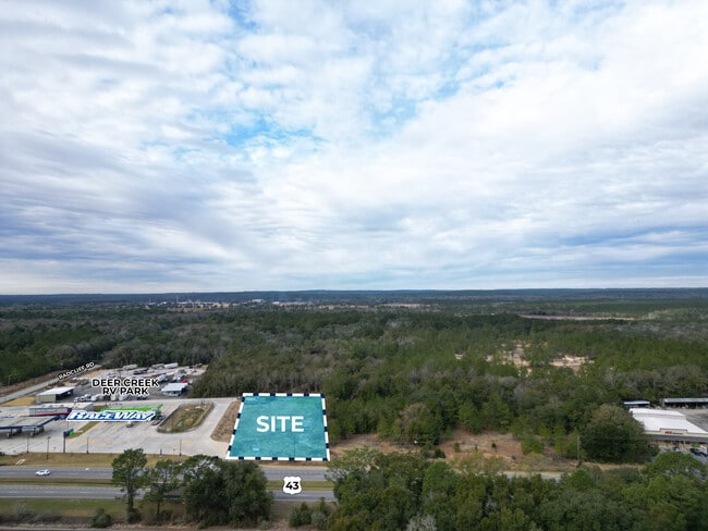
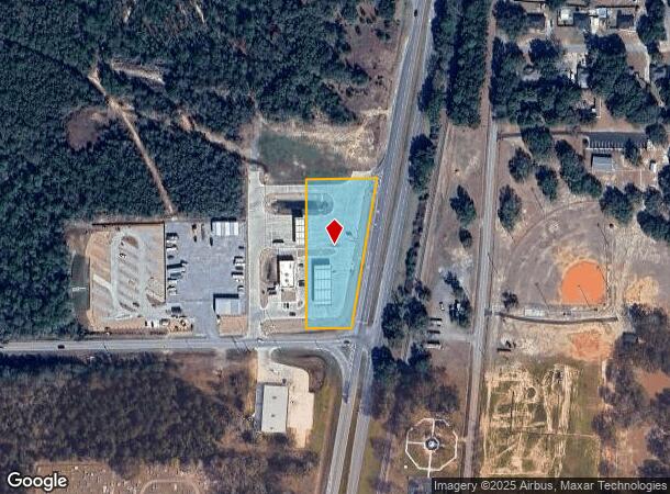
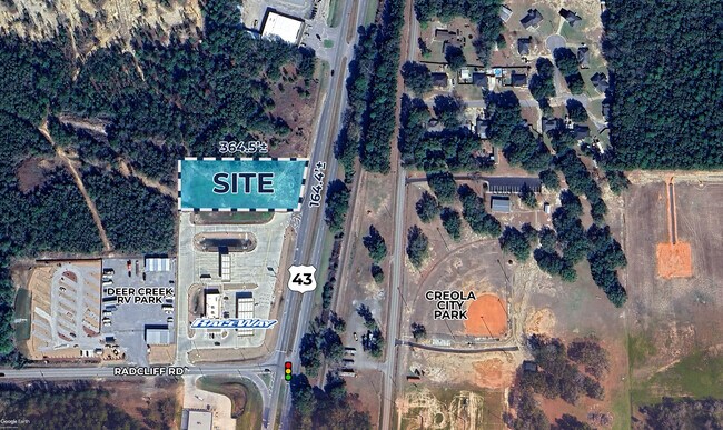
Property Record
10033 Highway 43, Creola, AL 36525
NEARBY LISTINGS FOR SALE OR LEASE
Property Detail
10033 Highway 43
Mobile, AL
PT OF PARCEL 9B OF HATTERS POND - RACETRAC ADDITION I 2022006876 BEING MORE PART DESC AS: COMM AT SE COR OF SAID PARCEL 9B TH R NELY 465 FT(S) TH W 220 FT(S) TH S 455 FT(S) TH E 135 FT(S) TO POB
19-01-01-0-000-028.031
Mobile
Realpropertynec
Alabama
2025
1.84 AC
2024
Outlying Mobile County
005702
Mobile
DEMOGRAPHICS near 10033 Highway 43
1 Mile
3 Mile
5 Mile
2024 Total Population
768
5,167
10,491
2029 Population
748
5,021
10,259
Pop Growth 2024-2029
(2.60%)
(2.83%)
(2.21%)
Average Age
41
42
41
2024 Total Households
303
2,008
4,003
HH Growth 2024-2029
(2.64%)
(2.84%)
(2.25%)
Median Household Inc
$49,895
$75,296
$78,495
Avg Household Size
2.50
2.60
2.60
2024 Avg HH Vehicles
2.00
2.00
2.00
Median Home Value
$152,758
$177,400
$171,010
Median Year Built
1984
1983
1981
Nearby Places
- Restaurants
- Banks
- Shops
- Fitness
- Groceries
PUBLIC TRANSPORTATION
AIRPORT
Mobile International
DRIVE
WALK
Distance
Mobile International
29 min
21.8 mi
Mobile Regional
DRIVE
WALK
Distance
Mobile Regional
38 min
24.4 mi
Freight Ports
Port of Mobile
DRIVE
WALK
Distance
Port of Mobile
19 min
16.7 mi
Nearby Properties
Address
Land Use
TOTAL SIZE
Lot Size
Zoning
Address
Land Use
TOTAL SIZE
Lot Size
Zoning
6,150 SF
46.96 AC
Address
Land Use
TOTAL SIZE
Lot Size
Zoning
30,870 SF
219.28 AC
Address
Land Use
TOTAL SIZE
Lot Size
Zoning
41,607 SF
2.96 AC
Address
Land Use
TOTAL SIZE
Lot Size
Zoning
82,000 SF
14.35 AC
Address
Land Use
TOTAL SIZE
Lot Size
Zoning
10,356 SF
8.20 AC
Address
Land Use
TOTAL SIZE
Lot Size
Zoning
77,083 SF
10.23 AC
Address
Land Use
TOTAL SIZE
Lot Size
Zoning
9,317 SF
1.64 AC
Address
Land Use
TOTAL SIZE
Lot Size
Zoning
19,250 SF
220 AC
Address
Land Use
TOTAL SIZE
Lot Size
Zoning
50,000 SF
12.97 AC
Address
Land Use
TOTAL SIZE
Lot Size
Zoning
16,000 SF
8.73 AC
Address
Land Use
TOTAL SIZE
Lot Size
Zoning
262.30 AC
Address
Land Use
TOTAL SIZE
Lot Size
Zoning
12,400 SF
10.11 AC
Address
Land Use
TOTAL SIZE
Lot Size
Zoning
8,150 SF
3.56 AC
Address
Land Use
TOTAL SIZE
Lot Size
Zoning
6,233 SF
27.08 AC
Address
Land Use
TOTAL SIZE
Lot Size
Zoning
9,600 SF
4.75 AC
Address
Land Use
TOTAL SIZE
Lot Size
Zoning
3,732 SF
183.97 AC
Address
Land Use
TOTAL SIZE
Lot Size
Zoning
7,433 SF
1.21 AC
Address
Land Use
TOTAL SIZE
Lot Size
Zoning
658 AC
Address
Land Use
TOTAL SIZE
Lot Size
Zoning
30,000 SF
20.40 AC
Address
Land Use
TOTAL SIZE
Lot Size
Zoning
11,100 SF
7.22 AC
Address
Land Use
TOTAL SIZE
Lot Size
Zoning
8,000 SF
5.80 AC
Address
Land Use
TOTAL SIZE
Lot Size
Zoning
9,552 SF
6.58 AC
Address
Land Use
TOTAL SIZE
Lot Size
Zoning
10,660 SF
1.80 AC
Address
Land Use
TOTAL SIZE
Lot Size
Zoning
3,587 SF
1.23 AC
Address
Land Use
TOTAL SIZE
Lot Size
Zoning
9,545 SF
1.01 AC
Address
Land Use
TOTAL SIZE
Lot Size
Zoning
19,500 SF
2.25 AC
Address
Land Use
TOTAL SIZE
Lot Size
Zoning
8,024 SF
3.45 AC
Address
Land Use
TOTAL SIZE
Lot Size
Zoning
2,640 SF
1.53 AC
The World's #1 Commercial Real Estate Marketplace
Connect with us
© 2025 CoStar Group
The information above has been obtained from sources believed reliable. While we do not doubt its accuracy we have not verified it and make no guarantee, warranty or representation about it. It is your responsibility to independently confirm its accuracy and completeness. Any projections, opinions, assumptions, or estimates used are for example only and do not represent the current or future performance of the property. The value of this transaction to you depends on tax and other factors which should be evaluated by your tax, financial, and legal advisors. You and your advisors should conduct a careful, independent investigation of the property to determine to your satisfaction the suitability of the property for your needs.